
 |
| Photo by Nikos Tzivanakis |
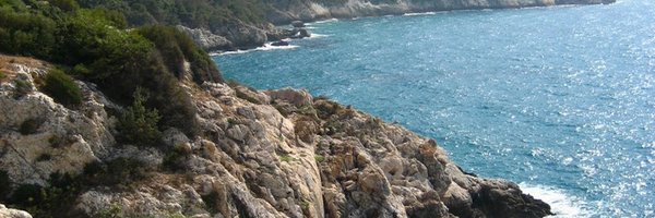
Samos is an ideal destination for hikers as, apart from its many stunning beaches, it also has two imposing mountain ranges with numerous walking paths. Lush forests with high trees, wild rocky land and streams are just some of the scenic and exciting natural features to be enjoyed there.
Along the way you will also discover the island’s herbs and animals, visit traditional mountain villages and take in striking panoramic vistas.
Paths:
Samos – Ag. Zoni – Kamara – Zoodochou Pigis Monastery – Kamara – Samos

Easy – medium challenge.
This only the final path on the hill towards the Zoodochou Pigis monastery, at an altitude of 300m, thus classifying this route a little above the "easy" category.
Distance: 15km, around 4 hours.
Samos – Prophitis Elias – Samos

Medium
The path starts at sea level at 400m., and although the paths and other parts are generally in good condition, some buried rocks can make the downhill part quite difficult.
Distance: 5.5km, around 2 hours.
Mesokampos – Mykali – Psili Ammos – Palaiokastro – Samos

Easy
There’s a little climbing involved in this hike, which travels around the coastline and leads you along good pathways.
Distance: 14.5km, around 2 hours.
Kokkari – Vourliotes – Manolates – Stavrinides – Agios Konstantinos
Medium – challenging
Around 600m of this trail is uphill, but is not continuously, as there are also level paths throughout.
Distance: 16km, around 4¼ hours.
Kampos – Vourliotes – Vrontiani Monastery – Kokkari


Medium - challenging
The route starts as a continuous uphill from paths that start at sea level and reach to 460m to a generally good road. Take it slow when descending the hill as some paths are very rocky, while even the stone paths are a little slippery.
Distance: 10km, around 3¼ hours.
Potami – Mikro Seitani – Kosmadaioi – Nikoloudes – Tsourlei – Palaio Karlovasi – Karlovasi
Medium - challenging
The uphill trek, taking you from sea level to around 475m is demanding. The rest of the hike is a comfortable downhill.
Distance: 18km, around 4¾ hours.
Potami – Mikro Seitani – Megalo Seitani – Drakaioi

Medium - challenging
A wavy beachside walk that reaches a height of around 375m. Be aware that most of the pathways are very narrow and rocky. Some hikers find the parts of this trail between Mikro Seitani and Megalo Seitani dizzying.
Distance: 10km, around 2¾ hours.
Karlovasi – Palaio Karlovasi – Kosmadaioi – Mikro Seitani – Potami – Karlovasi

Challenging
Kosmadaio is located at a height of 600m and the ascent from the sea level is sometimes very steep, but at least most of the path is well shaded. Some of the paths and trails along this trail demand attentive walking, so watch your step and take your time.
Distance: 21.5km, around 5 hours.
Karlovasi – Palaio Karlovasi – Kastro – Potami – Tsourlei – Palaio Karlovasi – Karlovasi
Easy – medium
The hike includes some uphills, at the start at around 140m and again on the way back from Potami on. The final uphill comes after around two hours, and it is recommended hikers avoid the Alternative walk.
Distance: 15.5km, around 3¾ hours.
Kosmadaioi to Marathokampos
Medium
Recommended only to experienced hikers as finding the road can be very difficult at around the point between 35 minutes and 1 hour into the walk, while there is also a danger of experiemcing dizziness during this hike.
Distance: 10km, around 2.5 hours.
Votsalakia - Evangelistrias Monastery – Vigla – Votsalakia

Very challenging
Only for experienced, very fit hikers. The ascent in this walk is at 1440m and almost all the hike take place along very abrupt, rocky ground. The peak is usually obscured by clouds, especially in spring and autumn, so it’s advised you avoid heading there during these times, and check weather conditions when you plan to head there. Be prepared also for freezing temperatures at the peak.
Distance: 21km, around 6.5 hours.
Platanos – Konteika – Ydrousa – Kontakeika – Agios Dimitrios

Medium
Although the hike begins with some climbing at around 150m, there are not big uphills along this route. There are the normal amounts of ups and downs, but the paths are generally quite level.
Distance: 15km, around 3.5 hours
Koutsi – Neochori – Koumeika – Ormos – Marathokampos

Easy – medium
Most of this hike is downhill. The only challenging part comes upon arriving on the rocky part of the path reaching the beach, which requires some flexibility.
Distance: 11km, around 2.5 hours.
Pandrosos – Lazaros – Kokkari


Challenging
The hike starts at 600m, involving around 550m of climbing, mostly at the beginning of the trail when you’re still energetic.
Distance: 17km, around 4.5 hours.
Pandrosos – Prophitis Elias – Manolates – Platanakia

Challenging
Pandrosos is at an altitude of around 600m, which leaves around 540m of climbing in order to reach the highest point, and that’s at the start of the route.
Distance: 19km, around 4 hours.
Mavratzeoi to Kokkari
Medium
The ascent takes you to an altitude of around 400m, but there are many undulations along the footpaths and walkways that are generally in good condintion.
Distance: 13km, around 3 hours.
Mavratzeoi to Mytilinioi

Easy
You’ll start walking along various pathways, but the main route is along one path and the uphills are mild.
Distance: 11km, around 2.5 hours
Hora – Myli – Heraion – Pythagorio


Easy – medium
The only challenging aspect of this hike is the distance walked, as this route is generally flat and involves a little bit of easy climbing. The hike ends with a walk around the beach.
Distance: 20km, around 4 hours.
Mytilinioi to Kokkari

Easy
Although this route includes a little bit of climbing, it generally takes you along easy and good paths parallel to one road.
Distance: 9km, around 2 hours
Mytilinioi – Vrontiani Monastery – Vourliotes – Platanakia

Medium
This route will take you to an altitude of 460m, yet getting there is not very difficult as the paths are not steep and are generally in very good condition.
Distance: 16.5km, around 3¾ hours.
Mytilinioi – Agia Triada – Spiliani Monastery – Pythagorio
Easy
Almost throughout the entire trail, the paths are pleasant and easy to walk along. The only slightly challenging part is during the downhill part, along a dusty trail, which may have hidden traps.